After a heavy rain event over the weekend, more of the same is anticipated to begin the week.
According to the National Weather Service in Wichita, areas of rain and thunderstorms will increase from the southwest Monday morning into the afternoon. Pockets of strong to severe thunderstorms along with very heavy rainfall are possible.
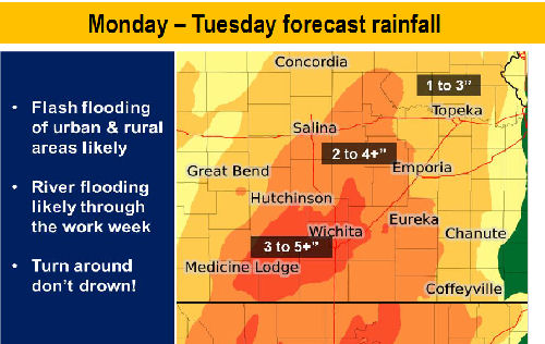
Very heavy rainfall is expected Monday afternoon through midday on Tuesday across central and eastern Kansas. Rainfall in excess of three inches is likely with locally higher amounts a good possibility. This will result in significant rises on area rivers and creeks with some exceeding flood stage. Locally intense rainfall could also result in flash flooding of urban and rural areas.
There is also a risk for severe storms across central and eastern Kansas on Monday afternoon through Monday night. Half dollar size hail and wind gusts to 60 mph will be possible across the area.
If a warm front can move north into southern Kansas on Monday evening, then a few supercell storms will be possible, capable of very large hail and tornadoes. Strong damaging wind gusts to 75 mph will also be possible early Tuesday morning, mainly across far eastern Kansas.