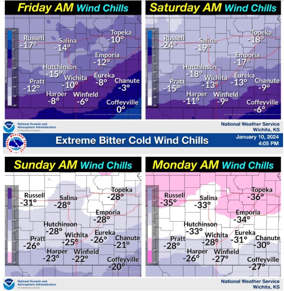
A couple of rounds of inclement winter weather are on the way, in the form of accumulating snow and dangerously cold temperatures.
According to the National Weather Service, late Thursday night into Friday light to moderate snow is possible across Central Kansas, with 1 – 3 inches possible. Along with the snow, bitter cold air will arrive, and settle into the area.
By the weekend and into early next week, high temperatures will be in the single digits. Overnight lows will drop below zero, with the chill as cold as 30 degrees below zero.
More snow is possible by late Saturday and into Sunday, with an inch or more possible.
_ _ _
Thursday Night – Snow, mainly before midnight. Patchy blowing snow after 10pm. Low around 7. Wind chill values as low as -13. Blustery, with a north northwest wind 16 to 23 mph, with gusts as high as 34 mph. Chance of precipitation is 80%. New snow accumulation of 1 to 2 inches possible.
Friday – Patchy blowing snow before 4pm. Partly sunny, with a high near 16. Wind chill values as low as -13. Blustery, with a northwest wind 15 to 23 mph, with gusts as high as 34 mph.
Friday Night – Mostly clear, with a low around -2. Northwest wind 8 to 11 mph.
Saturday – Partly sunny and cold, with a high near 9.
Saturday Night – A 30 percent chance of snow after midnight. Mostly cloudy, with a low around -7.
Sunday – A 40 percent chance of snow, mainly before noon. Mostly cloudy and cold, with a high near 1.
Sunday Night – Mostly cloudy, with a low around -11.
M.L.King Day – Mostly sunny and cold, with a high near 6.
Monday Night – Partly cloudy, with a low around -9.