A strong storm system will push very rich moisture northward into Kansas for Tuesday into Wednesday. Moderate to heavy rainfall is likely for late Tuesday night into Wednesday morning. The greatest risk for flooding to occur will be across central Kansas due to saturated ground soils and rivers already running higher than normal.
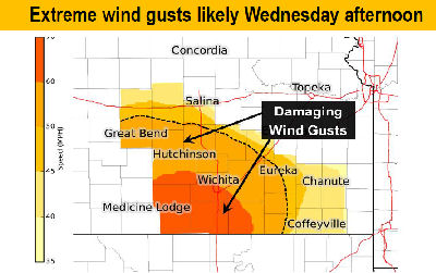
Extreme south winds will develop across the area Wednesday afternoon with wind gusts around 60 mph possible. The winds could cause damage to tree limbs, power lines, and light weight outdoor furniture or trash cans. Please take precautions to secure light weight outdoor items that could be blown away or damaged by wind gusts around 60 mph.
A High Wind Watch is in affect for Wednesday afternoon and evening across south central Kansas, and central Kansas for Wednesday night and Thursday. South wind gusts will increase to possible extreme levels for Wednesday afternoon and evening as a powerful weather system moves into the region. Winds will then switch to the northwest for Wednesday night into Thursday. Very strong winds will be possible again for central Kansas on Thursday. Please take precautions for any light weight outdoor items that could be blown away or damaged by winds gusts around 60 mph. In addition, the extreme south winds will elevate the grassland fire danger to extreme levels Wednesday afternoon and on Thursday.
Widespread 1 to 2 inches of rain will fall across the entire region Tuesday into Wednesday morning. Ground soils are saturated with rivers running higher than normal due to recent snow melt across central Kansas. As a result, a flood watch is in effect for Tuesday night through Wednesday for central Kansas where the risk for flooding problems is higher.