Preliminary groundwater level measurements compiled by the Kansas Geological Survey show mixed results for western and south-central Kansas in 2023, with some areas in the northwest and west-central part of the state experiencing increases for the first time in three or more years.
“In the Ogallala portion of the High Plains aquifer, the aquifer had a chance to ‘reset’ in 2023, given some timely rains in the summer months,” said Brownie Wilson, KGS water-data manager.
Measurements in those areas reflect a rebound from lower-than-normal groundwater levels caused by the extreme drought conditions seen in 2022.
“Unfortunately, south-central Kansas missed out on those rains, and the dry conditions persist today,” Wilson said.
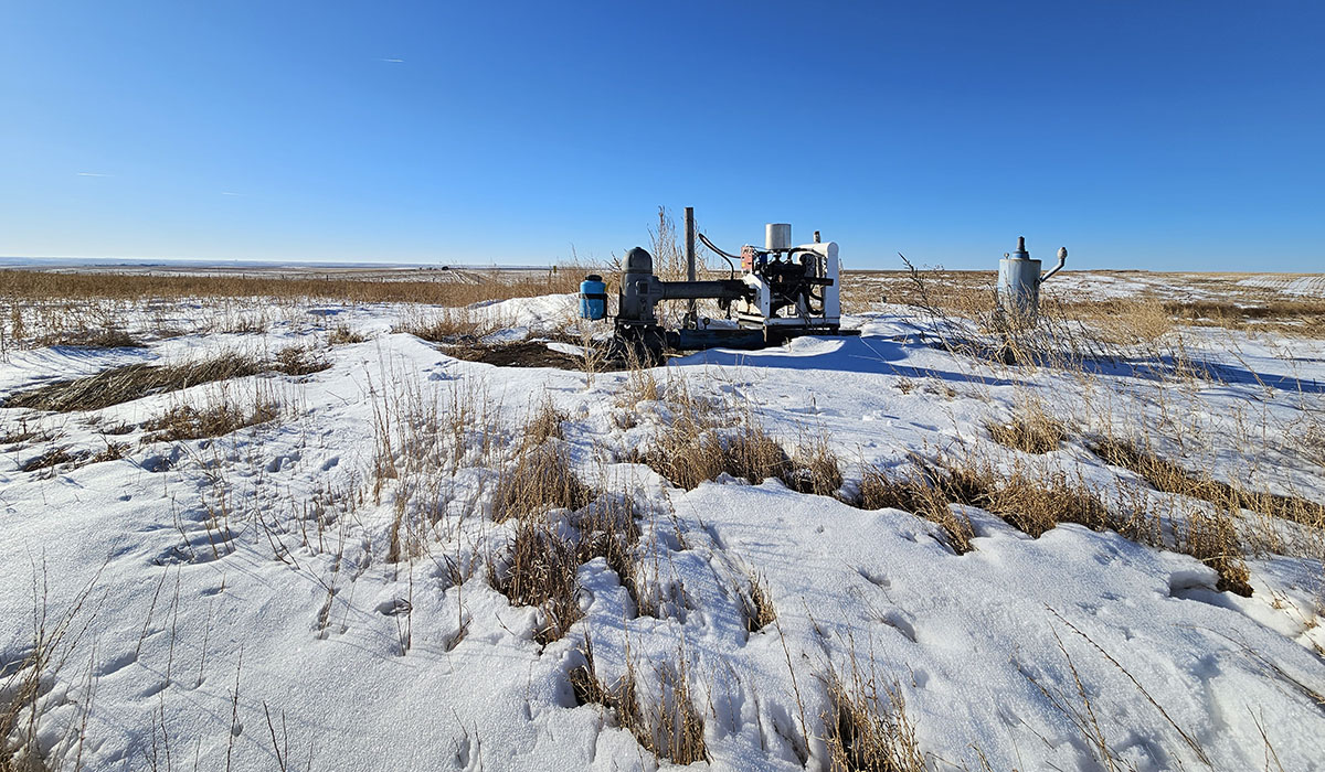
The KGS, based at the University of Kansas, and the Division of Water Resources (DWR) of the Kansas Department of Agriculture measure water levels in about 1,400 wells every year to monitor the health of the High Plains aquifer and other aquifers in western and south-central Kansas.
Those measurements showed an overall average decline of 0.17 feet last year, marking the fourth straight year of overall declines. Groundwater levels across the region fell 1.9 feet in 2022, about a foot in 2021 and 0.87 feet in 2020.
The High Plains aquifer is a network of water-bearing rock that extends into eight states. In Kansas, the aquifer comprises three components – the Ogallala aquifer, the Great Bend Prairie aquifer and the Equus Beds. Of these, the Ogallala underlies most of western Kansas and consists mainly of the Ogallala Formation, a geologic unit that formed from sediment eroded off the uplifting Rocky Mountains.
Most of the wells in the network monitored by the KGS and DWR are within the boundaries of the state’s five groundwater management districts, which are organized and governed by area landowners and local water users to address water-resources issues.
Northwest Kansas GMD 4, which saw well-above-average precipitation in 2023, experienced the largest increase in water levels, at 0.35 feet, after declines of 1.32 feet in 2022 and 0.55 feet in 2021. Groundwater levels last increased in the district, by 0.61 feet, in 2019. GMD 4 covers Sheridan, Sherman, Thomas, and parts of Cheyenne, Decatur, Gove, Graham, Logan, Rawlins and Wallace counties. Groundwater there is pumped from the Ogallala aquifer and shallow alluvial sources associated with streams.
Western Kansas GMD 1, where the majority of wells are drilled into the Ogallala aquifer, also saw an overall average increase of 0.27 feet, following declines of 1.13 feet in 2022 and 0.55 feet in 2021. The monitoring program has recorded increases in district water levels only three times since 1996, the last time in 2004. GMD 1 includes portions of Greeley, Lane, Scott, Wallace and Wichita counties. Water levels in the district, one of the first areas of the state to have large-capacity wells drilled in the 1940s-1950s, have fallen to a point that yields for irrigation have greatly diminished.
“Another factor in play is both GMDs 1 and 4 have active enhanced management plans in place to conserve water. Initial studies have shown water users are reducing both total amounts diverted and how much is applied to irrigated fields,” Wilson said.
In Southwest Kansas GMD 3, average groundwater levels declined by 0.19 feet. The region experienced the most severe drought conditions in the state in 2022, with widespread areas receiving 50% to 75% of long-term precipitation averages. The same area in 2023 saw above-average precipitation amounts of up to 150% to 200% of normal. Much of that came during the growing months of April through July.
“The timeliness and gentle nature of the precipitation events allowed many producers to shut down their wells for several weeks, which in turn reduces the overall stress on the aquifer,” Wilson said.
Water levels in GMD 3 declined by 2.83 feet in 2022 and 2.08 feet in 2021. The district includes all or part of Finney, Ford, Grant, Gray, Hamilton, Haskell, Kearny, Meade, Morton, Seward, Stanton and Stevens counties. Most of the wells monitored in the district are drilled into the Ogallala aquifer, except in a few areas where they can also draw from the deeper Dakota aquifer.
Water levels in south-central Kansas saw a second straight year of larger than normal decline rates amid continuing drought conditions.
Equus Beds GMD 2, a significant source of water for Wichita, Hutchinson and surrounding towns, experienced the largest drop at 1.62 feet, after declines of 2.11 feet in 2022 and 0.14 feet in 2021. GMD 2 covers portions of Harvey, McPherson, Reno and Sedgwick counties.
Water levels in Big Bend GMD 5, centered on the Great Bend Prairie aquifer, fell 1.12 feet in 2023, following declines of 2.32 feet in 2022 and 0.81 feet in 2021. GMD 5 includes Pratt and Stafford counties and parts of Barton, Edwards, Kiowa, Pawnee, Reno and Rice counties.
“Despite the prolonged drought conditions and lingering groundwater declines, both districts have a greater potential to recover when the rains do return,” Wilson said.
The KGS measured 577 wells in western Kansas, and DWR staff from field offices in Stockton, Garden City and Stafford measured 221, 264 and 350 wells, respectively, in western and south-central Kansas. Most of the wells, spread over 49 counties, are used for irrigation and have been measured for decades with landowners’ permission.
Measurements are taken primarily in January, when water levels are least likely to fluctuate due to seasonal irrigation. The measurement results, available on the KGS Water Well Levels web page, are provisional and subject to revision based on additional analysis.
The Kansas Geological Survey is a nonregulatory research and service division of the University of Kansas. KGS researchers study and provide information about the state’s geologic resources and hazards, including groundwater, oil and natural gas, rocks and minerals, and earthquakes.