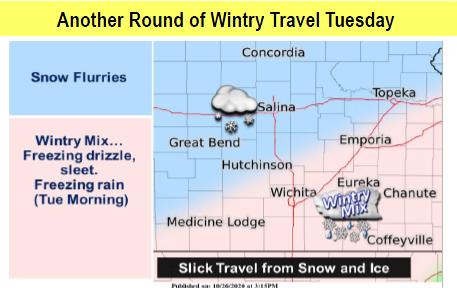
Another round of wintry travel can be expected overnight through early Tuesday. Then warmer weather is on the horizon.
According to the National Weather Service, freezing drizzle, sleet and freezing rain affect much of southern Kansas. Additional ice accumulations around one tenth to a quarter of an inch will be possible across southern Kansas, with the heaviest ice accumulations east of the Kansas Turnpike.
Snow flurries will be possible across central Kansas.
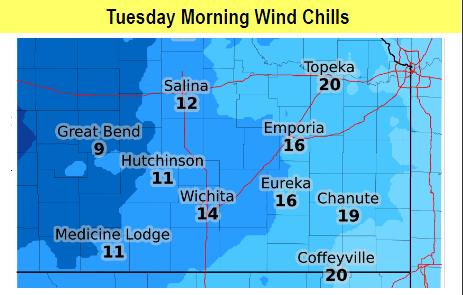
Bitter cold wind chills are also anticipated, dropping some into the single digits in some areas.
A gradual warm up is then expected for the rest of the week, leading up to Halloween.
Tuesday
A chance of snow before 2pm, then a slight chance of drizzle and snow between 2pm and 4pm, then a slight chance of drizzle after 4pm. Partly sunny, with a high near 37. North wind 5 to 8 mph. Chance of precipitation is 30%.
Tuesday Night
Mostly cloudy, with a low around 25. Light southwest wind.
Wednesday
A chance of sprinkles and flurries before 11am, then a chance of sprinkles between 11am and 1pm, then a chance of rain after 1pm. Mostly cloudy, with a high near 46. Calm wind becoming north northeast around 6 mph in the afternoon. Chance of precipitation is 50%.
Wednesday Night
Rain. The rain could be heavy at times. Low around 36. Chance of precipitation is 80%.
Thursday
Rain likely before 1pm, then a slight chance of drizzle after 1pm. Mostly cloudy, with a high near 48. Chance of precipitation is 70%.
Thursday Night
Mostly clear, with a low around 28.
Friday
Sunny, with a high near 55.
Friday Night
Mostly clear, with a low around 37.
Saturday
Sunny, with a high near 60.